Site Design and Engineering
Design engineers use a topo survey as the existing surface to plan the proposed final grade. It allows them to calculate earthwork quantities and balance cut and fill so dirt does not need to be hauled on or off the site.

Topo Surveys & Elevation Mapping for {{COUNTY}} County
Topographic surveys and contour mapping for engineers, architects, builders, and developers, from our licensed surveyors serving {{COUNTY}} County and the surrounding areas of {{STATE}}. Accurate elevation data for site design, grading, and construction planning.
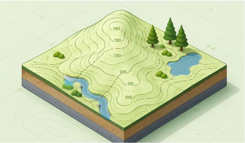
A topographic survey, or topo survey for short, maps the natural and man-made features of a parcel of land, along with the elevation of the ground surface. Unlike a boundary survey that focuses on property lines, a topo survey captures the shape of the land itself - showing hills, slopes, drainage, and grade changes as contour lines and spot elevations.
The survey also locates above-ground improvements like buildings, utility poles, and retaining walls, as well as underground utilities like water and sewer lines. Elevation changes are shown as contours - lines connecting points of equal elevation - typically at a 1-foot interval. Spot elevations at critical points can be accurate to a tenth or even a hundredth of a foot, giving engineers and architects the precise data they need to design.
A topographic survey is needed whenever a project requires accurate elevation and site feature data. If any of these apply to your project, a licensed surveyor can help.
Design engineers use a topo survey as the existing surface to plan the proposed final grade. It allows them to calculate earthwork quantities and balance cut and fill so dirt does not need to be hauled on or off the site.
A topographic survey provides the elevation and drainage data engineers need to design grading plans before construction begins. Accurate contours prevent drainage problems, flooding, and costly regrading down the line.
Most municipalities in {{COUNTY}} County require a topographic survey or site plan showing existing contours before issuing building permits for new construction or major site work.
Architects use topo surveys to understand the site before design - and may plot the surface in three dimensions to visualize the finished project for owner and public presentations.
On sites limited by steep slopes, existing features, or adjacent structures, a precise topo survey ensures the designed improvement fits within the property boundaries and site limitations.
Developers use topographic surveys to assess a site before purchase or design - identifying which areas are buildable and which require special engineering solutions.
Not sure if you need a topo-survey? Call {{PHONE}} and we'll help you figure it out.
There are two common methods for completing a topographic survey. The right method depends on the accuracy your project requires and the size of the site.
An aerial topo survey uses a drone with a camera (photogrammetry) or a LiDAR sensor to collect elevation data quickly over large or hard-to-walk sites. Ground control points measured by the surveyor tie the aerial data to the survey datum. Accuracy is typically lower than conventional shots on hard surfaces, so this method is best for large sites and early design. Learn more about our drone LiDAR mapping services.
A conventional topo survey is done on the ground by a surveyor using a total station or survey-grade GPS. The surveyor walks the site taking shots - horizontal location and elevation - at set intervals and along all breaklines. This method is used when the contour interval and spot elevations must be precise, such as for designing a sanitary sewer that needs to be within a hundredth of a foot.
When your topographic survey is complete, you receive a detailed map showing all required features and elevations. A typical topo survey in {{STATE}} includes:
Lines connecting points of equal elevation, showing the shape and slope of the land at your specified contour interval (typically 1-foot).
Precise elevation points at critical locations - accurate to a tenth or hundredth of a foot - such as curbs, drainage points, and grade breaks.
All natural and man-made features - buildings, driveways, fences, retaining walls, trees, utility poles, and pavement edges.
Above-ground and underground utilities including water, sewer, storm drain, power, and communications lines where visible or located.
An electronic file with all spot shots and breaklines included, so engineers and architects can build a 3D digital terrain model for design.
Deliverables in CAD-compatible formats (DWG, DXF) for direct integration with civil engineering and site design software.
Topographic survey costs vary based on the size of the site, the contour interval required, the density of features, and the terrain. A small residential lot costs less than a large commercial site or a heavily wooded parcel that requires more field time to map.
Factors that affect the cost include property size and acreage, the required accuracy and contour interval, the amount of vegetation and site features, and whether conventional or aerial methods are used. Larger or more detailed surveys take more field and office time.
To get an accurate quote, call {{PHONE}} or send us:
Our licensed surveyors serve property owners, lenders, and real estate professionals throughout {{COUNTY}} County and the surrounding areas of {{STATE}}.

Send us a quick inquiry below for your land surveying needs and we will get back to you within 2-3 business days.
Or Call us at:{{PHONE}}